|
This marker was located near 35° 45.204′ N, 85° 58.198′ before it went missing.
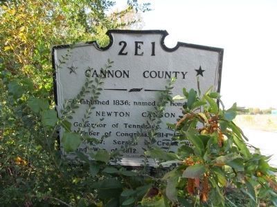
2E1 Cannon County Established 1936; named in honor of Newton Cannon Governor of Tennessee 1835 - 1839 Member of Congress 1814 - 1817 Served in Creek War and War of 1812 |
|
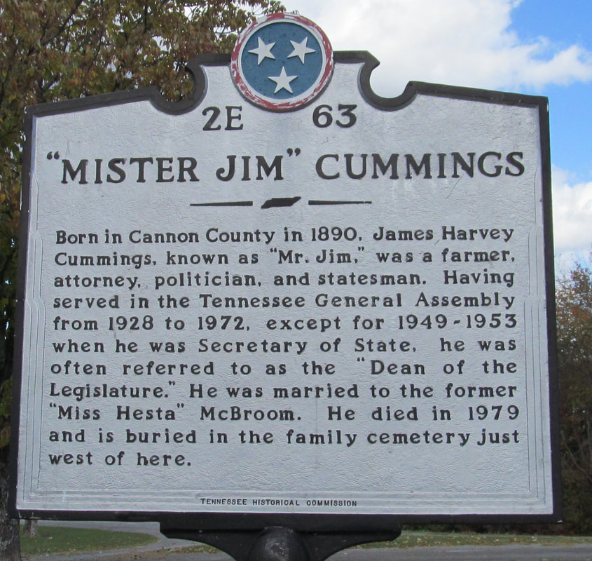
2E 63
35° 48.744′ N, 86° 1.722′ W Born in Cannon County in 1890, James Harvey Cummings, known as "Mr. Jim," was a farmer, attorney, politician, and statesman. Having served in the Tennessee General Assembly from 1928 to 1972, except for 1940-1953, when he was Secretary of State, he was often referred to as the "Dean of the Legislature." He was married to the former "Miss Hesta" McBroom. He died in 1979 and is buried in the family cemetery just west of here. |

|
2E 22
35° 49.564′ N, 86° 3.454′ In the valley to the south, that part of the Cherokee Nation which took part in the enforced overland migration to the Indian Territory rested for about three weeks in 1839. About 15,000 persons of various ages took part in the march. Several who died while here were buried in this area. |
|
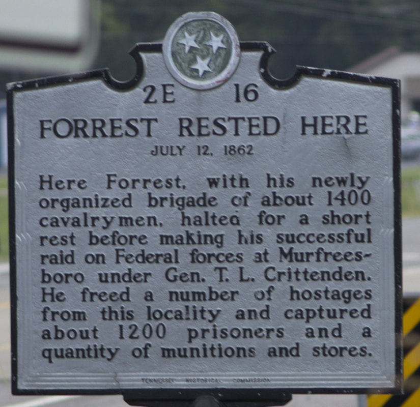
2E 16
35° 49.565′ N, 86° 3.457′ W Forrest Rested Here July 12, 1862 Here Forrest, with his newly organized brigade of about 1400 cavalrymen, halted for a short rest before making his successful raid on federal forces at Murfreesboro under General T.l. Crittenden. He freed a number of hostages from this locality and captured about 1200 prisoners and a quantity of munitions and stores. |
|
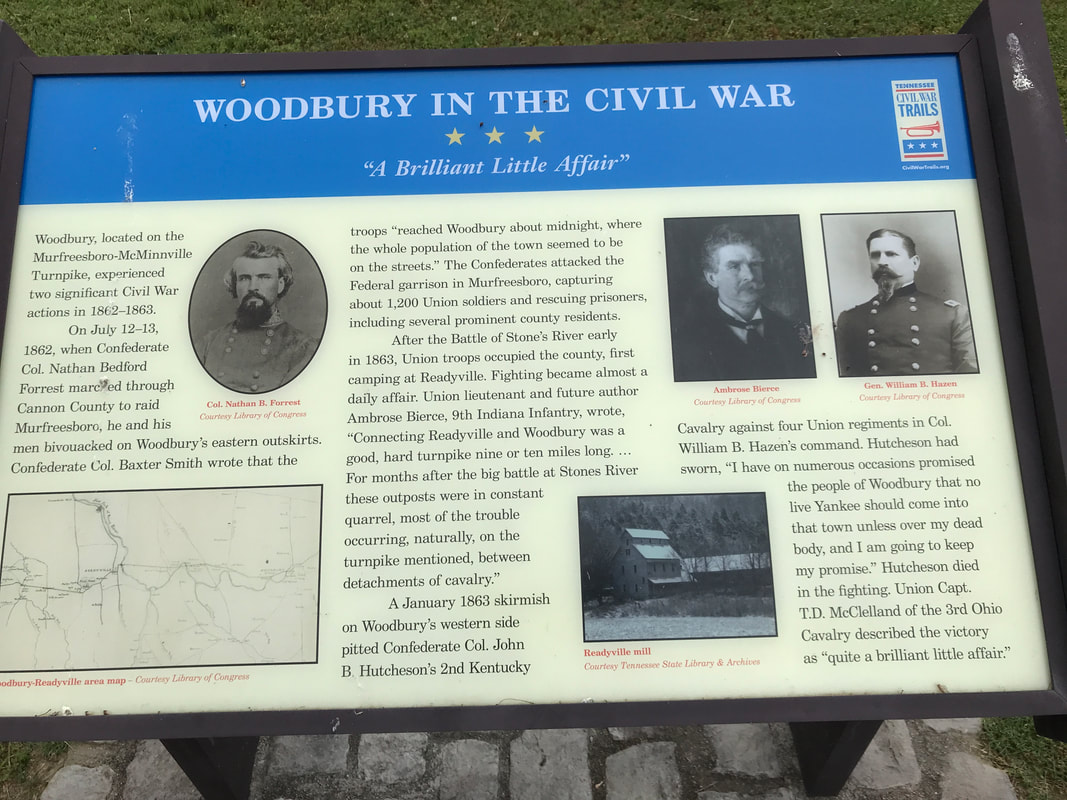
Woodbury In The Civil War
35° 49.674′ N, 86° 4.219′ W Woodbury, located on the Murfreesboro-McMinnville Turnpike, experienced two significant Civil War actions in 1862–1863. On July 12–13, 1862, when Confederate Col. Nathan Bedford Forrest marched through Cannon County to raid Murfreesboro, he and his men bivouacked on Woodbury's eastern outskirts. Confederate Col. Baxter Smith wrote that the troops "reached Woodbury about midnight, where the whole population of the town seemed to be on the streets.” The Confederates attacked the Federal garrison in Murfreesboro, capturing about 1,200 Union soldiers and rescuing prisoners, including several prominent county residents. After the Battle of Stone's River early in 1863, Union troops occupied the county, first camping at Readyville. Fighting |
became almost a daily affair. Union lieutenant and future author Ambrose Bierce, 9th Indiana Infantry, wrote, "Connecting Readyville and Woodbury was a good, hard turnpike nine or ten miles long. ... For months after the big battle at Stones River these outposts were in constant quarrel, most of the trouble occurring, naturally, on the turnpike mentioned, between detachments
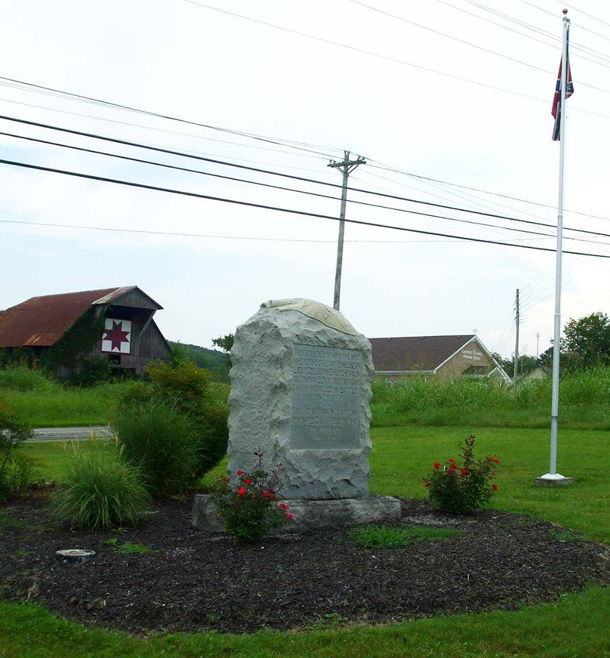
A January 1863 skirmish on Woodbury's western side pitted Confederate Col. John B. Hutcheson's 2nd Kentucky Cavalry against four Union regiments in Col. William B. Hazen's command. Hutcheson had sworn, "I have on numerous occasions promised the people of Woodbury that no live Yankee should come into that town unless over my dead body, and I am going to keep my promise.” Hutcheson died in the fighting. Union Capt. T.D. McClelland of the 3rd Ohio Cavalry described the victory as "quite a brilliant little affair."
A January 1863 skirmish on Woodbury's western side pitted Confederate Col. John B. Hutcheson's 2nd Kentucky Cavalry against four Union regiments in Col. William B. Hazen's command. Hutcheson had sworn, "I have on numerous occasions promised the people of Woodbury that no live Yankee should come into that town unless over my dead body, and I am going to keep my promise.” Hutcheson died in the fighting. Union Capt. T.D. McClelland of the 3rd Ohio Cavalry described the victory as "quite a brilliant little affair."
|
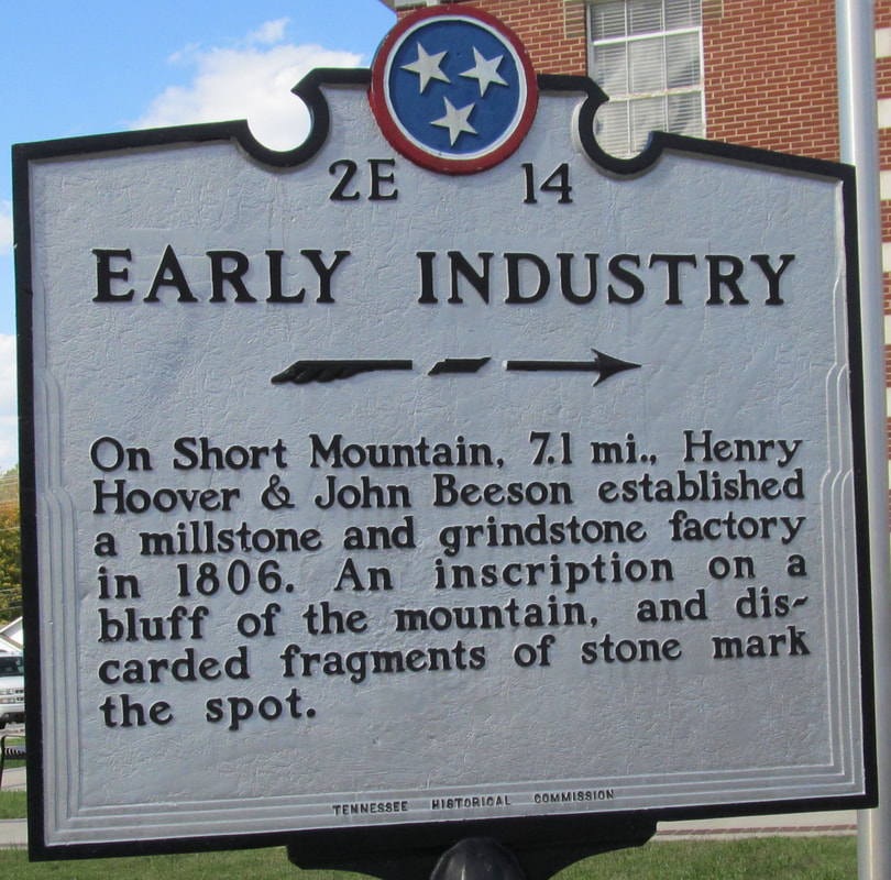
2E 14
35° 49.681′ N, 86° 4.247′ W On Short Mountain, 71. mi., Henry Hoover and John Beeson established a millstone and grindstone factory in 1806. An inscription on a bluff of the mountain and a discarded fragments of stone mark the spot. |
|
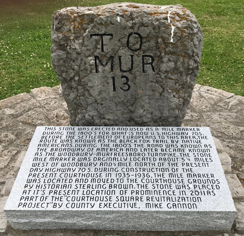
35° 49.702′ N, 86° 4.244′ W
To Mur 13 This stone was erected and used as a mile marker during the 1800's for what is now U.S. Highway 70S, before the settlement of Europeans to this area, the route was known as the Black Fox Trail by Native Americans. During the 1800's the road was known as the Broadway of American and later became known as the Woodbury-Murfreesboro Turnpike. The stone mile marker was originally located about 5.5 miles West of Woodbury and .5 mile north of the present day Highway 70S. During construction of the present courthouse in 1935-1936, the mile marker was located and moved to the courthouse grounds by historian Sterling Brown. The stone was placed at it's present location of prominence in 2011 as part of the "Courthouse Square Revitalization Project" by the County Executive, Mike Gannon. |
|
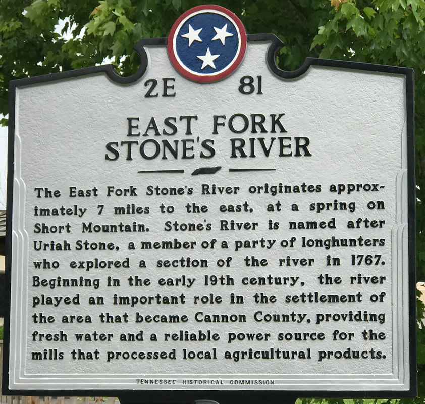
2E 81
35° 49.691′ N, 86° 4.214′ W East Fork Stone's River The East Fork Stone's River originates approximately 7 miles to the east, at a spring on Short Mountain. Stone's River is named after Uriah Stone, a member of a party of longhunters who explored a section of the river in 1767. Beginning in the early 19th century, the river played an important role in the settlement of the area that became Cannon County, providing fresh water and a reliable power source for the mills that processed local agricultural products. |
|
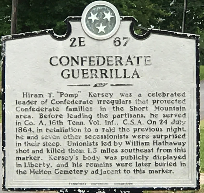
2E 67
35° 52.082′ N, 85° 55.345′ W Confederate Guerrilla Hiram T. 'Pomp" Kersey was a celebrated leader of the Confederate illegulars that protected Confederate families in the Short Mountain area. Before leading the partisans, he served in Co. A, 16th Tenn. Vol. Inf., C.S.A. On 24 July 1864, in retaliation to a raid the previous night, he and seven other secessionists were surprised in their sleep. Unionists led by William Hathaway shot and killed them 1.5 miles southeast from this marker. Kersey's body was publicly displayed in Liberty, and his remains were later buried in the Melton Cemetery adjacent to this marker. |
|
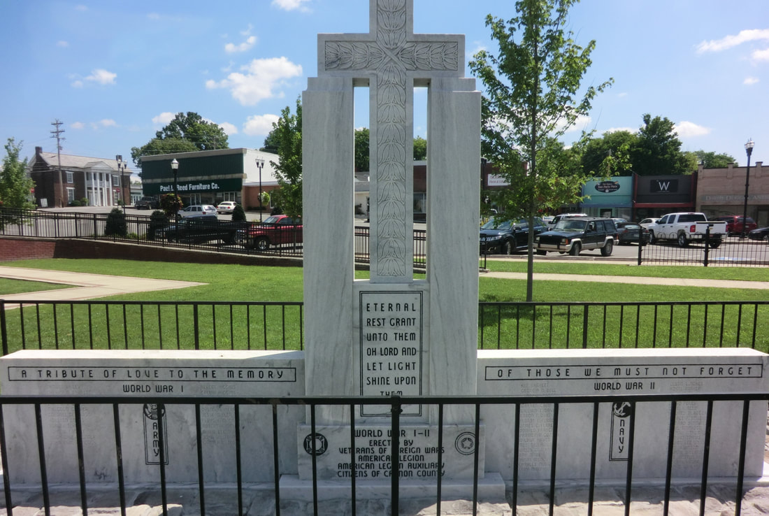
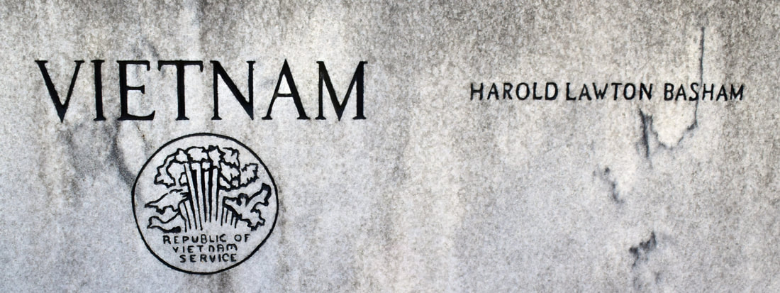
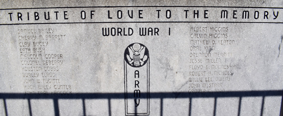
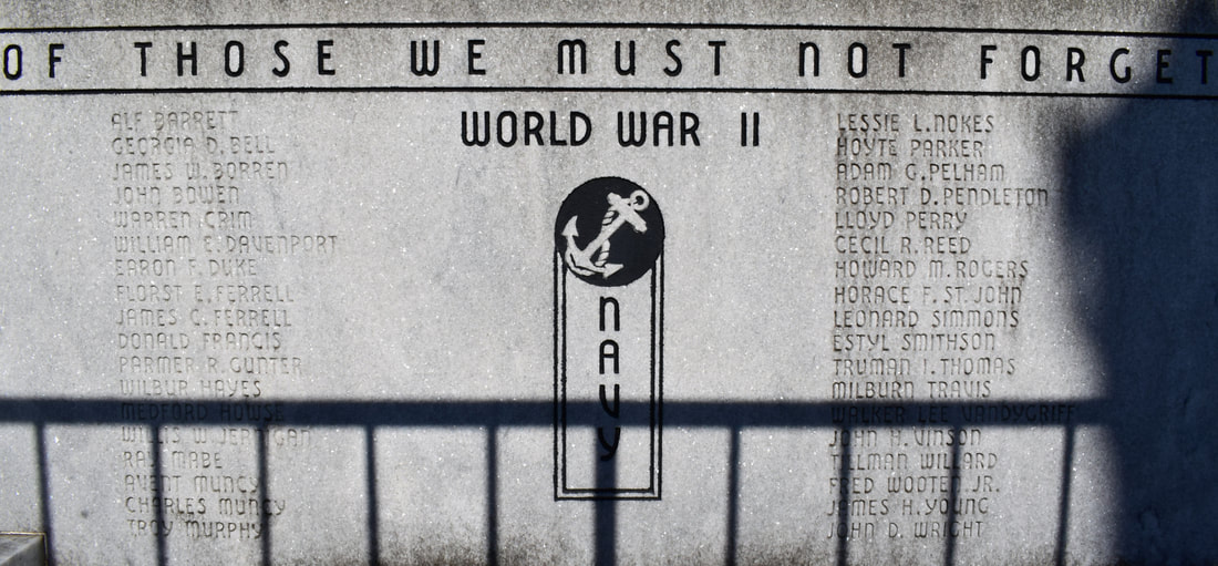
War Marker
35° 49.679′ N, 86° 4.232′ W A tribute of love to the memory of those we must not forget-World War I-Army- World War II-Navy Eternal rest grant unto them oh Lord and let light shine upon them. World War I-II erected by Veterans of Foreign Wars, American Legion, American Legion Auxiliary, Citizens of Cannon County.
|
|
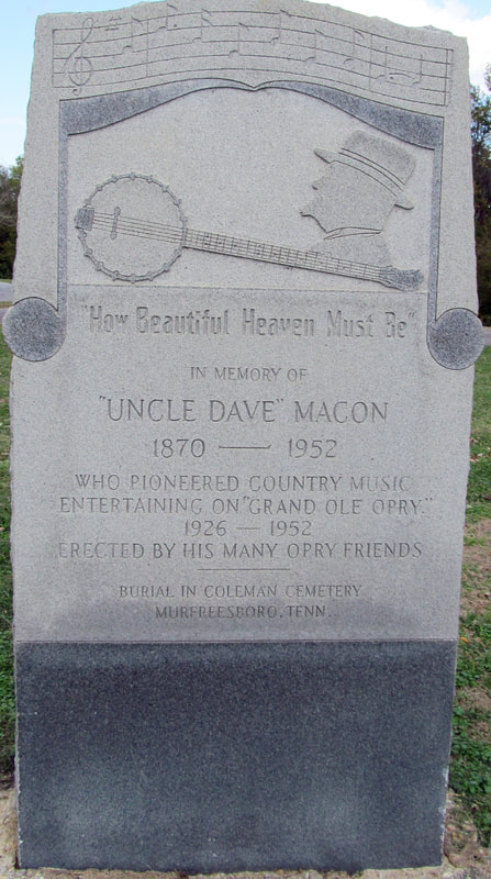
In Memory of 'Uncle Dave' Macon
35° 48.744′ N, 86° 1.722′ W 1870-1852 Who Pioneered Country Music Entertaining On 'Grand Ole Opry.' 1926-1952 Erected by his many Opry friends Buried in Coleman Cemetery, Murfreesboro, TN |
Erected by the Cannon County Chapter United Daughters of the Confederacy
July 1926. |
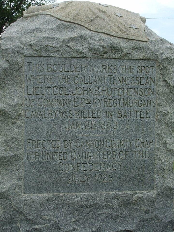
This boulder marks the spot where the gallant Tennessean Lieut. Col. John B. Hutchenson of Company E 2nd KY Regt. Morgan's Cavalry was killed in battle Jan. 25, 1863
|
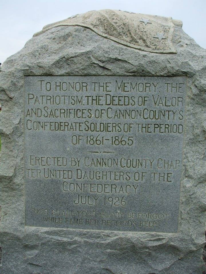
To honor the memory of the patriotism. The deeds of valor and sacrifices of Cannon County's Confederate soldiers of the period of 1861-1865
|
|
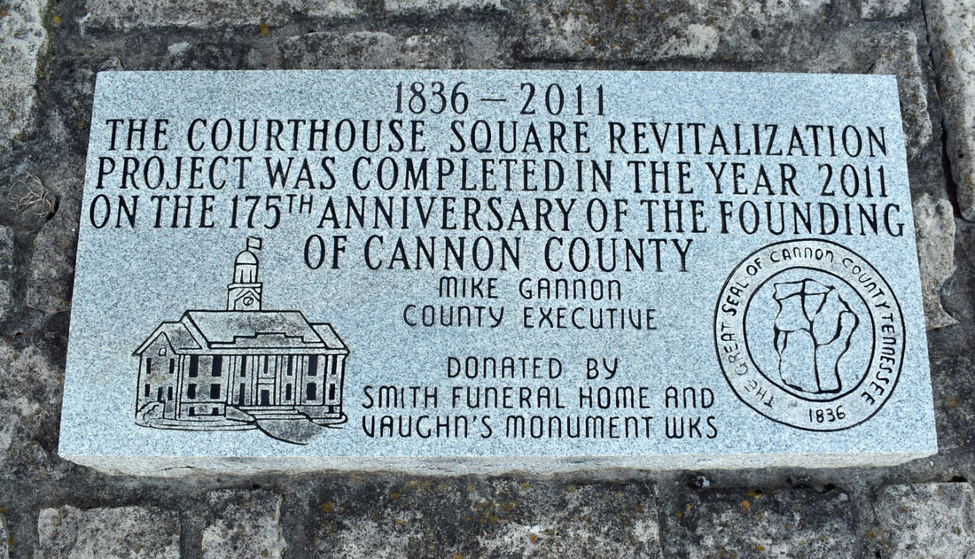
1836 - 2011
The Courthouse Square Revitalization Project was completed in the year 2011 on the 175th Anniversary of the founding of Cannon County Mike Gannon - County Executive Donated by: Smith Funeral Home and Vaughn's Monument Wks |
|
